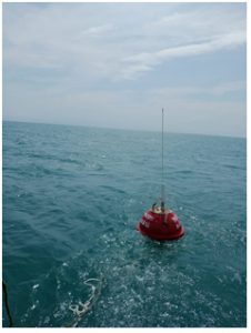
Getting real-time and live information from the ocean conditions like waves, current, sea surface temperature is crucial for forecasting ocean state conditions during disaster situation.

Now with the support of Earth System Science Organization – Indian National Centre for Ocean Information Services (ESSO-INCOIS), MSSRF has successfully deployed a new current meter wave rider buoy off Muttom, in Kanyakumari district, Tamil Nadu.
Prior information on the state of the seas surrounding the Indian subcontinent is vital for smooth operational activities not only for those venturing out into the sea but also for those on the shore. Forecasting of oceanographic parameters (both surface and subsurface) at different time scales is extremely important for a wide spectrum of users ranging from fishers to offshore industries. The users can take appropriate informed decisions based on the forecast sea state conditions, saving life and property.
Among the Indian Ocean Rim countries, India is endowed with a very long coastline of over 8100 km. INCOIS established the integrated Indian Ocean Forecasting System (INDOFOS), capable of predicting the surface and subsurface features of the Indian Ocean reasonably well in advance (5 to 7 days currently). As part of the process, INCOIS has deployed 16 wave rider buoys across Indian Ocean and Arabian sea in collaboration with various research organizations.
In Tamil Nadu and Puducherry there are three such wave rider buoys are deployed in Puducherry, Tuticorin and off Muttom, Kanyakumari by INCOIS in collaboration with MSSRF’s Fish for All Research and Training Centre. With shore stations in respective regions MSSRF monitors the functioning of buoys and ensures that data periodically goes to INCOIS for validation and preparation of advisories to the coastal communities.
On 28th November 2020, the new datawell current wave rider buoy was successfully deployed off Muttom, Kanyakumari with active support from the local parish priest, fishing community leaders and government authorities. The new data well current wave rider buoy measure the ocean conditions like waves, current, sea surface temperature on real time basis.
How it works
The Buoy collects data on ocean currents, waves and sea surface temperature on real time basis. It has two communication systems to send the data from the buoy. Through high frequency the collected data is sent to the shore station. The data are also transmitted to INCOIS and linked to INSAT helping gather real time information every thirty minutes. Ocean data from the Current WRB will be useful not only to validate the wave, current and Sea Surface Temperature (SST) forecasts from INCOIS for the oceanic region surrounding west coast but will also help in analysing and tracking high swell events originating from the Southern Ocean and arriving at the southwest coast of India. These observations will help further strengthen and enhance our capability to predict occasional High Wave events causing damages to coastal villages and fishing boats.
To ensure the buoy safety and easy retrieval, a ‘Buoy drift alert system’ has also been developed and implemented. All officials concerned, from MSSRF and INCOIS will receive alerts, in case the buoy drifts more than 200 metres from its position.
This deployment has meant yet another step forward in sea safety and advance warning systems for the Indian Ocean coast.
Written by: S Velvizhi
Edited by: Jayashree B

